Modeling Programs
Modeling is considered an iterative process. That is, the model can help to identify key areas of uncertainty where additional data collection can improve our conceptual understanding of the aquifer. As these additional data are collected and analyzed, the model can be updated to better reflect the improved conceptual understanding.
Groundwater Modeling
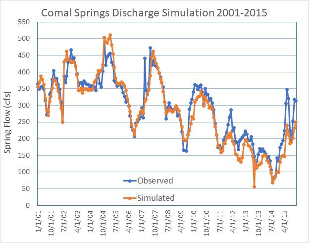
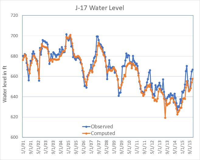
Groundwater flow modeling refers to the use of computational software to represent the physical processes that affect recharge to, storage within, movement through and discharge from the Aquifer. The EAA’s regional-scale groundwater model of the Edwards Aquifer was developed using the widely available MODFLOW 2000 software. Recharge and pumping estimates for years 2001—2015 are used as input to the model and the hydraulic properties of the model are calibrated so that model-predicted water levels and spring flows match real-life observations as closely as possible. The graphs below illustrate how the calibrated model predictions compare with observations of water levels in San Antonio Index Well J-17 and measured springflows at Comal Springs.
Once calibrated, the model can be used in a predictive manner to assess the potential benefits of groundwater resource management decisions. For example, the model can be used to evaluate a scenario of an extended period of below-normal recharge such as occurred in the 1950s—a period referred to as the drought of record– which resulted in cessation of flow from Comal Springs for several months in 1956. This scenario can be combined with modern-day pumping demands to assess the effectiveness of various conservation measures, such as Stage I—V pumping reductions, the Voluntary Irrigation Suspension Program, and the Aquifer Storage and Recovery Program.


Modeling is considered an iterative process. That is, the model can help to identify key areas of uncertainty where additional data collection can improve our conceptual understanding of the aquifer. As these additional data are collected and analyzed, the model can be updated to better reflect the improved conceptual understanding.