
 Aquifer Conditions
Projects
The EAA collaborates with many entities across a range of disciplines to better understand the Edwards Aquifer system. These projects go beyond the background data collection to help answer specific difficult questions.
Current Projects
-

Field Research Park
(FRP)

-
Interformational Flow
Monitoring
-
Continuous Water Quality
Monitoring
-
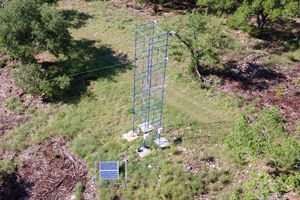
Evapotranspiration Data
Collection
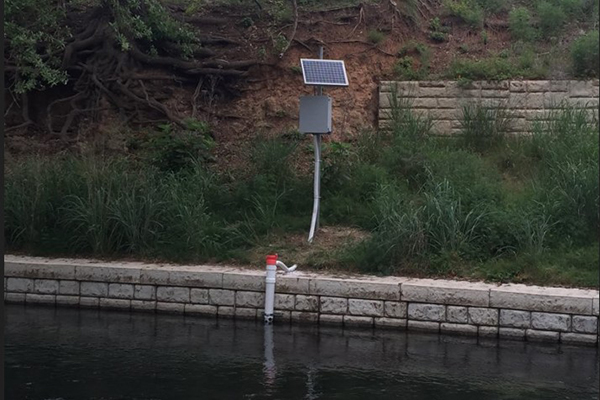
Continuous Water Quality Monitoring
The EAA operates six continuous water quality sondes in the Comal and San Marcos spring systems as part of the Edwards Aquifer Habitat Conservation Plan (HCP) program. Maps presented here show the locations of the three active sites at Comal Springs, and three active sites at San Marcos Springs. The names of the sites are:
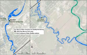 San Marcos Springs
- Sessom Creek
- San Marcos River at Aquarena Springs Drive
- San Marcos River at A. E. Wood Fish Hatchery
- San Marcos River at Rio Vista Park (Discontinued)
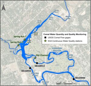 Comal Springs
- Comal Spring Run 3
- Comal Spring 7
- Comal River at Old Channel
- Landa Lake (Discontinued)
- Comal River at New Channel (Discontinued)
At each of these six monitoring sites, water quality instruments are installed that measure and record the following parameters in 15-minute intervals:
- Water Temperature
- Specific Conductivity
- Dissolved Oxygen
- pH
- Turbidity*
*only at Sessom site
These data are transmitted via telemetry to EAA servers daily. To request these data, please contact EAA Data Management at data@edwardsaquifer.org.
Hydrologic Data Reports
Annual Hydrologic Data Reports offer an extensive compilation of data on the Edwards Aquifer. The portion of the Edwards Aquifer discussed in these data reports is the San Antonio segment of the Balcones Fault Zone Edwards Aquifer that extends approximately 180 miles from a groundwater divide near Brackettville in Kinney County, Texas to a groundwater divide near Kyle in Hays County, Texas. For access to the underlying data, visit the EAA Environmental Data Portal.
Precipitation
 2022 Precipitation In The Edwards Aquifer Region
2021 Precipitation In The Edwards Aquifer Region
2020 Precipitation In The Edwards Aquifer Region
2019 Precipitation In The Edwards Aquifer Region
2018 Precipitation In The Edwards Aquifer Region
2017 Precipitation In The Edwards Aquifer Region
EAA 2016 Precipitation in the Edwards Aquifer Region
2022 Precipitation In The Edwards Aquifer Region
2021 Precipitation In The Edwards Aquifer Region
2020 Precipitation In The Edwards Aquifer Region
2019 Precipitation In The Edwards Aquifer Region
2018 Precipitation In The Edwards Aquifer Region
2017 Precipitation In The Edwards Aquifer Region
EAA 2016 Precipitation in the Edwards Aquifer Region
Recharge
Discharge & Usage
Water Quality
Fact Sheets & Hydrologic / Hydrogeologic Data Reports
2016-2015 Hydrological Data Report
2015-2014 Hydrological DatabReport
2015-2014 Hydrological Data Report Appendix C
2014-2013 Hydrological Data Report
2013-2012 Hydrological Data Report
2012-2011 Hydrological Data Report
2011-2010 Hydrological Data Report
2010-2009 Hydrological Data Report
2009-2008 Hydrological Data Report
2008-2007 Hydrological Data Report
2007-2006 Hydrological Data Report
2006-2005 Hydrological Data Report
2005-2004 Hydrological Data Report
2004-2003 Hydrological Data Report
2003-2002 Hydrological Data Report
2002-2001 Hydrological Data Report
2001-2000 Hydrological Data Report
2000-1999 Hydrological Data Report
1999-1998 Hydrologeologic Data Report
1998-1997 Hydrologeologic Data Report
1997-1996 Hydrologeologic Data Report
1996-1995 Hydrologeologic Data Report
1995-1994 Hydrologeologic Data Report
1994-1993 Hydrologeologic Data Report
1993-1992 Hydrologeologic Data Report
1992-1991 Hydrologic Data Report
1991-1990 Hydrologic Data Report
1990-1989 Hydrologic Data Report
1989-1988 Hydrologic Data Report
1988-1987 Hydrologic Data Report
1987-1986 Hydrologic Data Report
1986-1985 Hydrologic Data Report


