 Conditions
Managing The Edwards Aquifer
Our Job
When it comes down to it, our job is to make sure that just the right amount of water is drawn from the aquifer,
without taking too much.
Our Shared Responsibility
2.5 Million Texans – including farmers, cities and businesses – share this water source through a carefully maintained permitting system. As trusted stewards of the Edwards Aquifer, we’re charged with monitoring and preserving the unique springs and ecosystems that depend on its flow. Working hand-in-hand with our permit holders and community partners, we can ensure this vital resource remains healthy and sustainable for generations to come.
186 Billion Gallons – that’s how much water our permittees can draw each year. To date, our pumpers have never drawn one drop more.
Making sure there’s enough for everyone.
Water rights permits are a big part of effective aquifer management, since they help control and track the total amount of water being withdrawn from the aquifer. Through careful monitoring, we can prevent over-pumping that could lead to aquifer depletion or damage to dependent ecosystems like springs and rivers.
Responsible water rights permitting provides fair and balanced water use for everyone — from city services and farmers to industrial users and environmental needs.
Monitoring and tracking help us:
Understand how much water is being withdrawn
Make informed decisions during drought conditions
Plan for future water needs
Protect the rights of existing users
Understanding Index Wells
Have you ever heard of the J-17 or J027 Index wells and wonder what they mean? An index well is a monitoring well that we use as a reference point for measuring groundwater levels in the aquifer. Think of it as a “dipstick” that helps us track how much water is available. Index wells, like the like the J-17 and J-27, are strategically placed in locations that best represent water conditions across larger areas of the aquifer.
The Edwards Aquifer Authority maintains a strategic network of index wells throughout the region.
Real-time Monitoring Stations:
Index wells are critical monitoring points that give us real-time data on aquifer conditions. They help us continuously track water levels instead of periodic manual measurements.
Regulatory Triggers:
The J-17 serves as an official regulatory trigger in our drought management plan. When water levels cross certain thresholds, our conservation measures like pumping restrictions automatically kick in.
Historical Records:
Some of our index wells have continuous monitoring records dating back to the 1930s. These long-term datasets help our scientists better understand the aquifer through drought and wet cycles.
Daily High:
Each day, we measure the highest water level between midnight and 8 a.m. During heavy rain, we monitor rising levels throughout the day, so if the highest level is recorded later in the day we correct the reading.
Around-the-Clock Monitoring:
Water levels are measured around the clock using different devices in monitoring wells throughout the aquifer.
Groundwater withdrawal:
We use water level data from index wells to help determine when we may need to impose groundwater withdrawal reductions for permit holders.
The Importance of Spring Flows
Spring flows happen when water from the Edwards Aquifer naturally emerges at the surface through openings in the ground.
The EAA monitors key springs – particularly Comal and San Marcos Springs — as part of our overall management strategy. These natural springs are vital indicators of aquifer health and play a crucial role in the Edwards Aquifer Authority’s management plan.
Ecosystem Health
Changes in spring flow can indicate potential stress on aquatic ecosystems and endangered species that rely on consistent conditions.
Drought Protection
Declining spring flows often provide early warning signs of developing drought conditions before they affect wells.
Recharge
Spring responses after rainfall events help us understand how well the precipitation is replenishing the aquifer.
Human Impact
Changes in spring response to rainfall compared to historical patterns can reveal effects of increased pumping or land use changes.
When spring flows drop below certain thresholds, it triggers specific conservation measures in our management plan.
Critical Period Management
Our job is to balance the rate of water withdrawal with the natural recharge process
When index well levels and spring flows decline past these thresholds, the EAA kicks in its Critical Period Management (CPM) Plan to help maintain minimum levels.
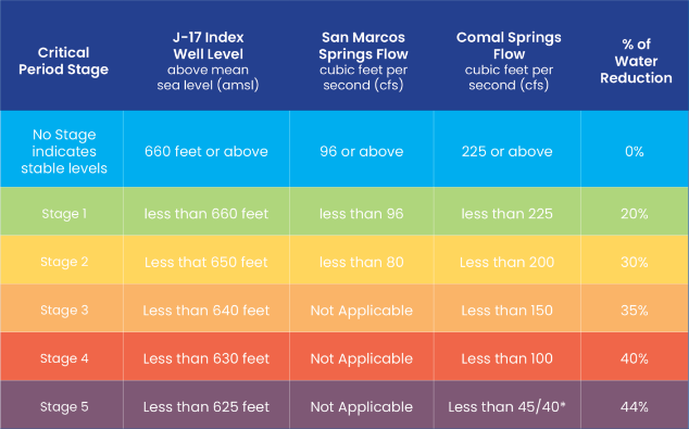
The San Antonio Pool
San Antonio Pool pumping permit reductions apply to Atascosa, Bexar, Caldwell, Comal, Guadalupe, Hays, and Medina counties.
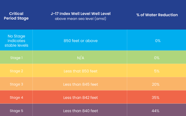
The Uvalde Pool
The Uvalde pool pumping permit reductions only apply to Uvalde County.
By tracking spring flows alongside index well measurements, we get a comprehensive picture of the aquifer’s condition. Then we can make science-based water management decisions that balance human needs with environmental protection.
Did You Know?
The pumping cap within our jurisdiction is 572,000 acre-feet per year. That’s enough water to fill over 280,000 Olympic-sized swimming pools.
Want To Get Involved?
The Edwards Aquifer Conservancy’s mission is to support and benefit the work of the Edwards Aquifer Authority.
Get involved.


